
Chris Fawkes,BBC Weatherand
Ian Aikman
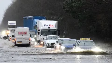
Flooding and travel disruption from Storm Chandra has continued, after the third named storm of the year lashed the country with heavy wind and rain on Tuesday.
Dozens of flood warnings, meaning flooding is expected, and more than 200 flood alerts, where flooding is possible, are in place across the UK.
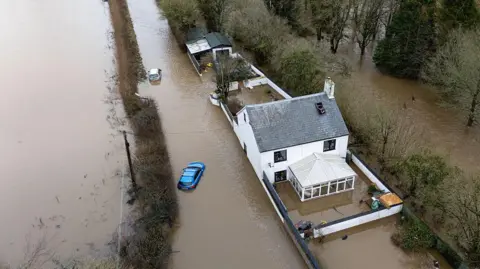
A major incident was declared in Somerset on Tuesday evening where around 50 properties were hit by floods. More disruption in the area is possible, and a yellow rain warning is in place for south-west England on Thursday.
That warning has been extended until 03:00 on Friday morning. A new yellow rain warning has also been issued for Northern Ireland on Friday.
National Rail has warned the poor weather could impact journeys until Friday across England, Scotland and Wales.
In Dorset, residents of the Iford Bridge Home Park have been advised to evacuate “as quickly as possible” with a bag of essential items and medications.
Power will need to be switched off ahead of the flooding, and residents must “prepare to be away from your home overnight”, the agency added.
Emergency service and local council staff are at the site to assist with the evacuation, it said.
The complex of about 80 homes on the banks of the River Stour was previously flooded last January and in November 2024.


Somerset council leaders have warned that more homes are likely to flood, despite drier weather forecast on Wednesday.
Eight schools are closed and several local roads are closed in the county.
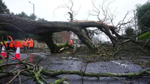
Storm Chandra arrived just days after Storm Ingrid caused major damage and disruption over the weekend, meaning rain fell on already saturated ground in many places.
Risk of flooding remains on Wednesday morning, with 85 flood warnings and 229 flood alerts issued across England.
 Charles McQuillan/Getty Images
After a cold start with a few icy patches, many areas will have dry weather with spells of sunshine on Wednesday.
In northeast Scotland, the leftovers from Storm Chandra will continue to bring some wet and windy weather. Showers are forecast in south Wales and southwest England, but these won’t make the flooding any worse.
More rain is forecast for both Thursday and Friday with around 10-20mm falling in southwest England, which may cause some further flooding problems.
Meanwhile, a spell of snow over the Pennines and Southern Uplands early on Friday could bring 2-7cm of snow above 200m elevation, causing tricky travelling conditions.
Tuesday saw two severe flood warnings, indicating danger to life, issued in England. Both have since been lifted.
They were issued for Upper Frome, Dorchester, and Ottery St Mary, Devon – where the Environment Agency said the River Otter had reached its highest recorded level.
“At the moment, it’s a raging torrent,” Jackie Blackford, whose house overlooks the river, told BBC Radio Devon on Tuesday. “It is horrendous – I’ve never seen anything like it.”
Schools were closed in some parts of England and Northern Ireland on Tuesday.
The heavy rain saw several locations – including Katesbridge in Northern Ireland, Mountbatten in Plymouth and Hurn in Dorset – set new January daily rainfall records.
In Northern Ireland, a peak of more than 10,000 properties were without power and more than 300 schools were closed. Peak wind gusts reached 80mph at Orlock Head on the Ards Peninsula.
Several domestic flights and ferry services were cancelled.
Outside the UK, the Electricity Supply Board (ESB) in the Republic of Ireland said around 20,000 homes, farms and businesses were without power on Tuesday.
Storm Chandra is the third major storm to hit the UK in January, arriving shortly after Ingrid and Goretti – the latter of which was described by the Met Office as among the most impactful to hit Cornwall and the Isles of Scilly in 30-35 years.
Additional reporting by Kathryn Armstrong, Chloe Gibson and Christine Butler
 PA Media
 Finnbarr Webster/Getty Images

Get our flagship newsletter with all the headlines you need to start the day. Sign up here.